Salutations, connected friends 🛜
As adventurers, we find ourselves drawn to the vastness of the open ocean. Yet, amidst the allure of the deep blue sea, there lies a fundamental need for reliable communication systems to ensure safety and peace of mind while venturing offshore.
This next post therefore concerns offshore communications. To be clear, this post is not an overview of all the options available for communications offshore. Instead, it provides our framework of thinking about the topic and describes our current setup and thoughts.
ℹ️ Getting information about the topic#
That being said, feel free to wander into this rabbit hole 🕳️🐇! Some resources we you might find useful include this post on the World Cruising Club website or this video by the amazing Sophie and Ryan (if you’re searching for your next awesome sailing YouTube channel, search no more!).
Additionally, with Starlink’s relatively recent entry into the market, a lot of the information that is conveyed is rapidly outdated. Starlink is quickly revolutionizing marine communication offshore. Exciting (and historic) times! 🤩
👀 Line-of-sight propagation#
In line-of-sight propagation [..] waves can only travel in a direct visual path from the source to the receiver without obstacles. This means that communications that rely on line-of-sight propagation are well suited for coastal navigation, but less so once you head offshore. And this is… 🥁… due to the curvature of the Earth! Isn’t it remarkable?
You therefore need a way to make signals either bounce off the atmosphere… or be relayed by satellites.
🕵️ What are you looking for?#
While we have made satellite communications work for decades now, the download speeds were low and prices very high, so you needed to parsimoniously define what were are looking for. Maybe you’re fine with just email 📧 ? Or you’d like to add messaging 💬 ? Voice calls 📞 and weather forecast downloads 🌦️ ?
With Starlink you can have all of the above and more, with the interfaces you use every day, that is, your apps, your browsers, your phone. In fact, you get so much connectivity that many a long-bearded sailor has started to reject Starlink so that they can remain disconnected (and more in touch with Nature 🌊) while sailing!
🛰️ Internet Connectivity & Satellite Phones#
Starlink#
Starlink is a satellite internet constellation operated by American aerospace company SpaceX, founded by Elon Musk. SpaceX started launching Starlink satellites in 2019, and announced reaching more than 1 million subscribers in December 2022, 1.5 million subscribers in May 2023, and 2 million subscribers in September 2023. It is also changing the face of maritime communications.
ARC+ 2023 historical moments#
You might have noticed that it’s hard for us to contain our excitement regarding Starlink. Indeed, this year’s ARC+ crossing was historical. The fleet was communicating via WhatsApp and Telegram channels everyday, sharing experiences, struggles, positions, local weather situations, no wind zones, and more. This is unheard of.
More than that, when Hilma dismasted, the first means of communication that worked for them (meaning with which they could effectively communicate with someone) were exactly these chat groups. By reaching out to these chat groups and thus to other boats, we (the fleet) were able to help the Hilma crew contact the ARC+ team, as well vessels near Hilma (using the YB tracker data). Read Hilma’s incredible story here.
Hardware, subscriptions and speeds#
The product continues to evolve rapidly, and so do pricing and conditions, which themselves depend on where you are based.
As of writing this post, you can expect to pay 600 or 2500 USD for the dish. As for the subscription plans:
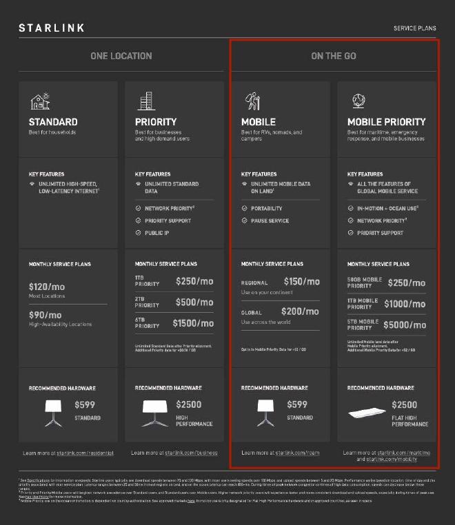
While this might sound like a lot of 💸, do bear in mind that you either get unlimited internet (when you’re at the marina or on a buoy) or, if you purchase limited internet (for offshore passages), the caps are quite generous. The same can be said of the speed 💨.
Pros and cons#
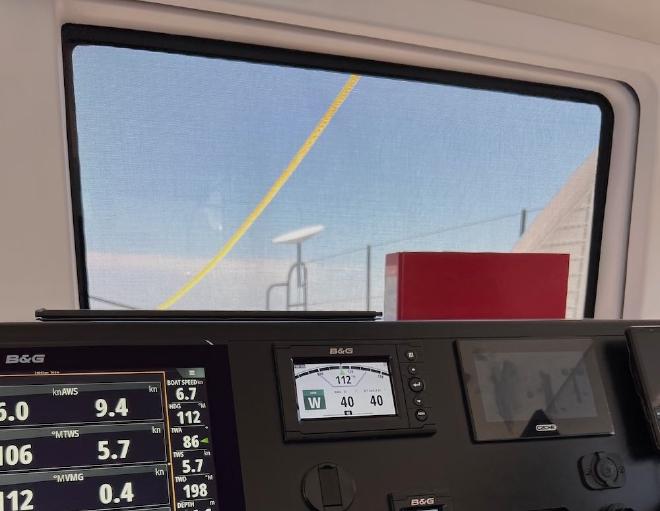
The last section pretty much speaks for itself in terms of pros. In addition, setting up the dish is fairly easy. We started off by having the Starlink on a fishing rod on our bow, but have since moved it to a permanent (and better!) installation on the davits, where it won’t get caught by the sheets.
Starlink offers nearly global coverage and worked flawlessly during our transatlantic crossing. One thing you need to know though is that Starlink requires a steady 220V supply in order to work. Therefore, you cannot take it with you on a liferaft and should think of backup solutions in case of power failure or ship evacuation.
With all these possibilities, it’s easy to let your guard down and consume data as you would at home or on land. But Starlink does have caps offshore and you probably have limits on your budget as well. During our crossing, we monitored our consumption (we were 5 people on board) and set a couple of golden rules for usages:
- All devices must be set to low data mode (for Windows users, see here);
- We avoided Instagram and other image intensive products;
- We did not use Netflix or any equivalent service.
If folks wanted to have access to large video or audio files, we asked them to download everything beforehand. In the end, we mostly took time to read and talk.
We were and continue to be really happy with Starlink 🤩!
Iridium Go! Exec#
Iridium Communications Inc. is a publicly traded American company which operates the Iridium satellite constellation, a system of 75 satellites (66 active and the remaining 9 as in-orbit spares). The satellites are placed in low Earth orbit (LEO) at a height of approximately 781 kilometres and provide global coverage. Iridium offers several solutions for satellite communications, the one we purchased being the Iridium Go! Exec.
A backup solution#
The Iridium Go! Exec was our backup for this transatlantic crossing. Iridium offers several plans for this device, including data plans capped at 250 GB for 500 USD. We however went with the more affordable PredictWind plan, which offers data for PredictWind forecast, our software of choice for passage planning on offshore passages.
| Technical specifications (Source: Iridium website) | |
|---|---|
| 📏 Dimensions (L x W x H) | 203mm x 203mm x 25mm |
| 🏋️ Weight | 1200 g |
| 🛰️ Iridium Embedded Technology | Iridium Certus 9770 Module |
| 🌡️ Operating Temperature Range | -20 to 50 ℃ |
| 💦 Ingress Protection | IP65 |
| 🪫 Battery Life, Talk Time | 6 hr |
| 🔋 Battery Life, Standby | 24 hr |
This device is water resistant (not waterproof), portable, has a built-in speaker and microphone and allows you to make satellite calls as well as use data.
Real-world experience#
However, the download and upload speeds are painfully slow. According to their own website, you can expect up to 22 Kbps upload and up to 88 Kbps download speeds. Thus, waiting for your weather forecast to download looks something like this. And while, in this video, Ryan and Sophie seem to have found a stable connection, this is not guaranteed. We have tried taking the device outside to get it to download some weather data and the mere act of attaining a stable connection under a clear sky ☀️ was no trivial feat 😮💨.
On top of this, pricing is tricky and full of clauses. Take the pricing for our PredictWind plan (taken from their website, once you click on “plan details”):
| PredictWind Plan Details | |
|---|---|
| Activation fee | 49.95 USD |
| Cost | 169.95 USD/month |
| Data | “Unlimited” PredictWind Data, but the fine print says that GRIB downloads in the PredictWind Offshore App are limited to 4MB/day |
| Voice minutes | 50 mins |
| Extra data | 10MB / 20MB / 30MB for 40 USD / 70 USD / 90 USD, respectively |
| Inbound voice calls | Free for recipient |
| Outbound voice calls to other Iridium phones | 0.55 USD/min |
| Outbound voice calls to mobile and landline | 0.70 USD/min |
| Outbound voice calls to other satellite phones | 12.63 USD/min |
It can quickly become expensive and the complexity of the system means that we not only need to spend quite a bit of time understanding how the product works, but also need to prepare to use it, that is, understand precisely what is needed if, for example, we need to communicate more than 50 minutes.
So why get the Iridium Go! Exec, you ask? Well, when we registered for the ARC+, Starlink was not a recognized means of offshore communication. However, during the year of 2023, the World Cruising Club changed its stance and accepted it. In the meantime, we had already purchased the Iridium Go! Exec. “Oh well”, we thought, “good for backup… and for the life raft.” 😉
Here is a table comparing our primary and backup communications systems:
| Starlink | Iridium Go! Exec | |
|---|---|---|
| 📞 Voice calls | 👍 Via messaging apps and to landlines via Skype | 👍 50 min |
| 🛜 Internet | 👍 Excellent speeds and intuitive usage | 👍 Very slow speeds and cumbersome to use |
| 🌦️ Weather forecasts | 👍 Via your software of choice | 👍 Plan available with PredictWind offshore |
| 🔌 Power | 220 V [1] | 5V |
| 🎒 Portable | No | Yes |
| 🪫 Battery life | No battery | 6h talk time, 24h in stand by |
| 💸 Pricing | Simple | Complex |
[1] There are several non-Starlink supported kits to change your hardware to a 12V system. However, we can’t recommend them. If you do make changes to your system, you’ll loose access to the Starlink Router interface, which will limit your ability to perform software updates and also quickly enable/disable features on the dish. We have some friends that did the change and things started to get weird (e.g., GPS chip starting to fail…).
KVH#
We have very limited experience with KVH VSAT systems, but from our experience thus far, we cannot recommend it.
Indeed:
- The system we originally got never worked (the motor that rotates the dish was delivered broken);
- Arranging a repair has been nearly impossible, with limited dealers and technicians with time to assist;
- The pricing system is completely opaque and tables intended to contain pricing details often just say “Contact KVH Sales for Pricing”;
- When you finally manage to shed some light on pricing, you realize how incredibly expensive it is.
📍 Automatic Identification System#
AIS#
The Automatic Identification System (or AIS, for short) is an automatic tracking system that uses transceivers on ships and is used by vessel traffic services (VTS).
Info transmitted by a transmitter includes the:
- Name of the boat;
- Call sign;
- MMSI;
- Speed over ground;
- Heading;
- … and more!
Any boat with an AIS receiver can then read and display that information. Note that a transmitter also includes a receiver, but some boats only have receivers. However, AIS signal transmission is limited to the VHF range, so about 10–20 nautical miles.
We use the Cortex VHF + AIS and we love it! Besides VHF and AIS transceiver, it contain other neats features such as an Anchor Watch, remote alarms and more.
PredictWind Datahub: enhanced AIS#
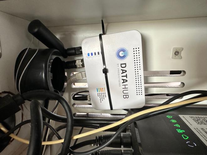
We have however expanded that range via the PredictWind Datahub. This piece of equipment not only serves as a GPS tracker, but it also can act as a surveyor and rebroadcast of AIS data from all surrounding vessels to a global AIS network (you have to enable this though). This allows you to increase your range of AIS detection from 10-20 nm to 300 nm, according the PredictWind website.
Installing it is easy:
🖲️ Personal Trackers#
(Enhanced) PLBs#
We have the PLB3 Personal Locator Beacons (PLB) installed on both our life-jackets. This product presents, to our eyes, several advantages:
- It can transmit a distress alert on the 406 MHz frequency (detected by satellites of the Cospas-Sarsat system)
- It also transmit a homing signal on the lower frequency of 121.5 MHz, to allow rescue vessels and aircraft to home in on the casualty
- It transmits an AIS locating signal
- It contains a GNSS receiver that uses the GPS and Galileo Satellites
All of this means that this PLB uses several means of providing a location of a casualty.
That suits us. We love backup plans 😉.
Satellite + GPS + Messaging Trackers#
We are avid snowboarders 🏂 and use trackers when venturing into the backcountry. As we thought of daring into the Atlantic Ocean, we decided we would take our trackers with us. We used:
- The Garmin InReach 2, with subscription plans here.
- The SpotX, with subscription plans here
With these two devices, we sent daily pre-defined check-in messages to an email group containing our Nuvem Mágica Guardians contacts.
In addition, the ARC+ organizers also gave us a YB unit for the ocean crossing. With this, the whole fleet was tracked.
📋 You’ve gotten the equipment… what now?#
Test it, test it, test it!#
To do testing, the best is to create a list as you simulate a scenario.
For example, let’s say I want to send a check-in message with my Garmin InReach personal tracker:
- How do I ensure that my tracker is charged?
- We had to make sure to bring the right cable and be mindful that when the device does not have a clear view of the sky 🌅, it will keep searching for signal, draining the battery.
- Does it have any other pre-requisites to work? Like some extra app or software? Or does it require any environmental constraint?
- The answer is yes! Our tracker needs a clear view of the sky, so we need to take the device outside for the daily check ins!
- How many email addresses can I send it to?
- Now is a good time to check the documentation. We sent the messages to a Google group (aka mailing list) in which all our Guardians were.
Be as thorough as you can:
- Test all the core functionalities you will rely on: do they work reliably?
- Test the emergency numbers while you’re at it:
- Do emergency services pick up the phone?
- How fast do they do so?
- Pretend you only have this one device:
- What can you do with it?
- What can’t you?
It helps to have some risk management concepts in your head here. Think about:
- What is the likelihood of something happening?
- And what are the consequences of said event?
An event that is unlikely and only mildly annoying when it happens is very different from an unlikely but life-threatening event!
Then, based on the risks that you perceive, what can you do to mitigate said risks?
Make it extremely easy to use#
In an emergency, a lot of folks freeze ❄️ and are overwhelmed 😣. You want protocols to be painfully obvious to reduce the likelihood of mistake or you/others forgetting what to do.
Here are some things we did on our atlantic crossing to make things easy to use:
- Removing the PIN from the Iridium Go! Exec device;
- Having emergency numbers on speed dial;
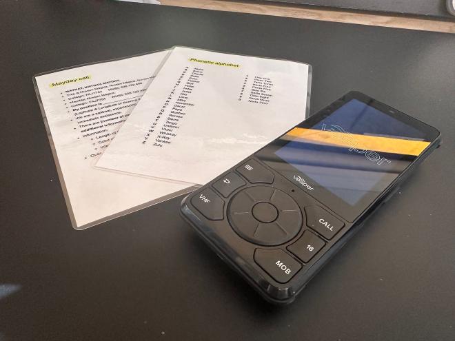
- Having MAYDAY, PAN PAN and other urgency calls as laminated cards people can read off of;
- And more…
💂 Guardians of Nuvem Mágica#
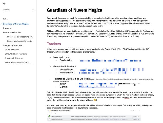
What if, despite all this preparation, there is a problem and we cannot communicate? This where our Nuvem Mágica Guardians come into play.
The Guardians of Nuvem Mágica are friends and family we ask to monitor our offshore trips. We share all our tracking information with them and send them daily check-in messages (and often more fun updates as well ❤️).
We ask our Guardians to closely watch over us. Specifically, we ask them to follow a detailed protocol in case we stop responding for >24 hours:
- Check our AIS information to understand the state of our vessel (Safe/Not Safe);
- Reach out to us using multiple channels (regular messaging apps first, using our trackers second);
- If we still do not respond, we ask our Guardians to alert the authorities or a set of pre-defined emergency contacts.
🎬 Conclusions#
We have covered yet another topic that would easily fill an entire book. We hope our efforts of summarizing how we went about preparing our offshore communication systems will help you think about your own setup.
In short, as with other topics, you should strive to have (1) a sound understanding of the technical aspects of the problems and solutions, as well as (2) a clear vision of the strengths and the limitations of each system, so you can think ahead and define your plans A, B, C (all the way up to Z?), should a situation arise during your offshore passage.
Stay safe and stay linked 🌐
Your Nuvem Mágica
